


Summary
-
The Issue
Groundwater (water stored underground) is critical for supporting life in much of inland Australia and citizen science can play an important role in monitoring its quality and sustainable use.
-
National Interest
Understanding more about the groundwater resources will underpin the sustainable development of northern Australia.
-
Project Tasks
An app, a website and water sampling kits have been developed to support the collection and analysis of groundwater samples. The samples will be analysed for a range of variables including conductivity/salinity, pH, hydrogen and oxygen isotopes, and environmental DNA, also known as eDNA.
-
Significance
This project will help communities in northern Australia monitor groundwater quality into the future and increase confidence in the management of this important resource.


Email To Action
You can obtain a kit by emailing Jenny.Davis@cdu.edu.au
Background
-
01 Why do we need to know more about Groundwater in Northern Australia?
Water is the basis of all life on Earth but groundwater (the water stored beneath the Earth’s surface) is often ‘out of sight and out of mind’, despite its importance as a permanent source of water in otherwise dry landscapes. Access to freshwater for drinking is vital for the existence of many towns and remote communities. Groundwater is also needed by the cattle industry, mining, agriculture and horticulture, it supports ecosystems and biodiversity, and plays an important role in culture and connection to country for Indigenous people. Understanding more about the groundwater resources that support life in the wet/dry tropics and arid regions of northern Australia, and to share this information, is the aim of this project. To do this we need to collect and analyse water samples from bores across the north of the NT and WA. Researchers alone cannot collect groundwater samples from such a large geographical area, but citizen scientists can! Anyone who uses the project app and groundwater sampling kit and returns the samples to us is a citizen scientist. Participating in this project will provide you with information about the water in your bore, whilst also helping us to understand the characteristics and variability in groundwater quality in the north. The results of this project will support sustainable development of the region and improve confidence that this important water resource is being monitored.
-
02 Project location
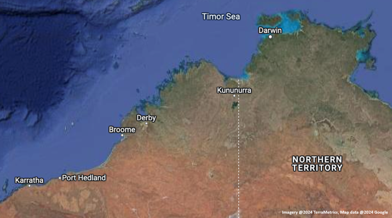
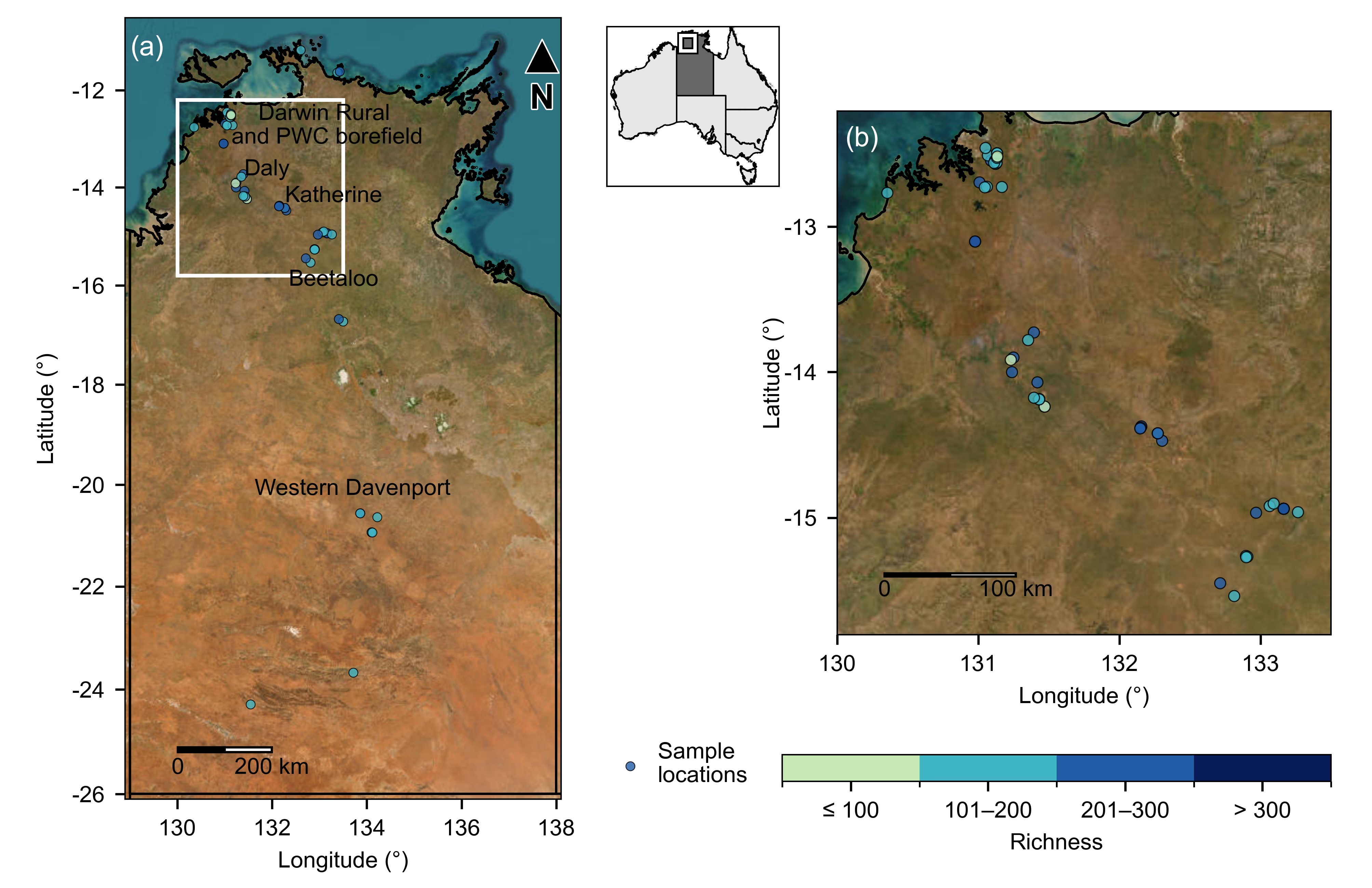
This image shows the regions of the Northern Territory & WA covered by this project
-
03 What data will be collected & what it will tell us?
For this project we need three 50 ml vials to be filled with water. At CDU we will use this water to measure electrical conductivity/salinity and stable isotope composition, and for baseline water banking. The kit contains universal indicator papers for you to measure pH directly and record on the app. An eDNA sampling kit is provided and subsequent analyses undertaken by the Wilderlab (a commercial laboratory) will be used to characterise aquatic biota and biodiversity.
-
04Electrical conductivity (EC)/salinity (one 50 ml vial)
Many organisms, including humans, need freshwater to survive, that is, water that contains low concentrations of salts. One of the easiest ways to measure the saltiness, or salinity, of water is to measure the electrical conductivity (EC). The ability of water to conduct a current provides a measure of the amount of salt (dissolved ions) in the solution. The EC of the 50 ml water sample collected from your bore will be measured with a lab-based meter at CDU and the results will be provided on the project website.
-
05pH (universal indicator paper)
Freshwaters can range in pH from very acidic (< 4) to neutral (7) to very alkaline (>9). Water is usually suitable for drinking if it is within the range of 6.5 to 8.5. You can measure the pH of a groundwater sample directly at your bore using the indicator paper and colour chart provided and entering the results onto the app.
-
06Stable isotopes of hydrogen & oxygen (one 50 ml vial)
The isotopic composition (δ18O and δ2H) of the 50 ml water sample collected from your bore will be measured in the lab at CDU using IRIS (isotope ratio infrared spectrometry). The isotopic composition provides information on whether the groundwater is mainly rain from the last major rain event, if the water has been retained for longer, or if it’s really ancient water (i.e. from rain that fell 100s or 1000s of years ago). This information makes a difference as to how we might use the resource. If it’s water from a recent rain event, then we know it's renewable. If it's very ancient water, it probably won’t be recharged, depending on the location of the aquifer, and we may need to be more cautious with water use.
-
07Baseline Water Banking (one 50 ml vial)
One 50 ml vial of water will be frozen at CDU and stored as part of a baseline water bank. If something happens in the future, and a bore is thought to be contaminated, another sample can be collected and sent to us to determine the difference in chemical composition between the two. The water bank provides a baseline against which future changes in water quality can be assessed. This is very useful where future developments, and their impacts, are not yet known.
-
08Environmental DNA (eDNA) (Wilderlab sampling kit)
Groundwater can contain organisms, including microbes, fungi and invertebrates (also known as stygofauna), that are adapted to living in subterranean environments. They can contribute to maintaining good quality water and their detection is an important part of understanding how they provide this valuable ecosystem service. Groundwater can also contain DNA shed from plants and animals living in terrestrial systems above the water table. Increasingly the measurement of eDNA is being used as a biomonitoring tool (using the presence of organisms to infer water quality) as well as an indicator of biodiversity (below and above ground) The measurement of eDNA is a two-step process. It involves first filtering the water to collect the DNA and then adding a preservative. Specific sampling instructions are provided with the DNA sampling kit.
-
09More about stygofauna
Stygofauna, also known as subterranean aquatic fauna, live in groundwater, often at considerable depths below the ground surface. Most are crustaceans, but stygofaunal communities can include mites, worms, snails, insects and fish. Because they live in the absence of light, stygofauna lack eyes and pigmentation. A recent study undertaken by scientists at CDU and CSIRO has provided the first description of stygofauna in the Beetaloo region of the NT
(Oberprieler, S, Rees, GN, Nielsen, D,Shackleton, M, Watson, G, Chandler, L. and Davis, J, (2021) Connectivity, not short-range endemism, characterises the groundwater biota of a northern Australian karst system. Science of the Total Environment. 796:148955)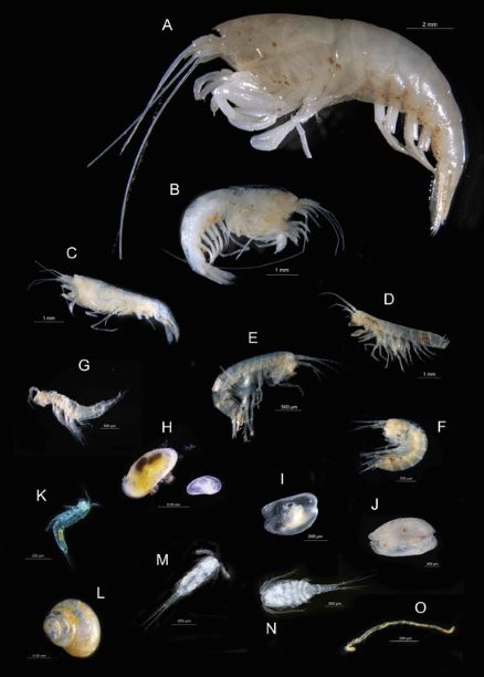
Results
Key Findings
- Most groundwater sampled across northern Australia was fresh and suitable for drinking and agriculture
- Every bore had a distinctive microbial community
- More than 1,000 different types of microbes (bacteria and other microorganisms) were detected
- Treated drinking water had much lower microbial diversity
- eDNA proved to be an effective tool for monitoring groundwater health
- The project established the first groundwater microbial baseline for northern Australia
Project Aims
Our main aim was to find out more about the quality of the groundwater in northern Australia. We wanted to know how fresh or salty, and acidic or alkaline, the groundwater is, because this indicates how suitable water is for drinking, and supporting cattle, crops, industry and biodiversity. We also wanted to know more about groundwater microorganisms because they control the processes that determine groundwater chemistry.
What We Did
- Developed a standardised groundwater quality sampling protocol that includes an app providing step-wise sampling instructions, a website for collecting and disseminating results, and a report card.
- More than 200 sampling kits were distributed. Around one-third were returned, and almost every returned sample produced usable DNA.
- The sampling locations spanned a 1,000 km tropical to arid zone climatic gradient from Warruwi on South Goulburn Island (-11.616669, 133.4305254) to Watarrka National Park (-24.291412, 131.549616) in central Australia.
- To examine changes across the north (tropical) to south (arid) climatic gradient we statistically analysed 41 bores assigned to six regions based on the criteria that four or more bores were sampled in that region, and their locations were representative of the region’s land use.
- We have also analysed treated drinking water sampled from four NT towns (Darwin, Katherine, Mataranka and Alice Springs) to as reference samples.
What We Found
- The lowest EC, 20.4 μS/cm, was recorded from a Darwin rural area bore, whilst the highest, 2,810 μS/cm, was recorded from an arid zone (Western Davenport) bore. Both the lowest pH, 6.17 (Watarrka National Park) and the highest pH, 7.98 (Western Davenport) were recorded from arid zone bores. Almost all the groundwater samples were fresh and close to neutral (pH~7 ) and were within the Australian Drinking Water Guidelines: EC <1,090 μS/cm, 6.6 < pH < 8.5. This result is not surprising because almost all the bores sampled were providing water for drinking, cattle or crops.
- Bacteria dominated in all samples, both in numbers and variety, with over 1000 types of bacteria and archaea (similar to bacteria but with a different evolutionary history) detected by eDNA analysis.
- Less common, but also important, groundwater biota detected included over 190 types of fungi, 90 amoebae and 65 ciliates.
- Treated water supplies contained only a tiny fraction of the microbial variety found in raw groundwater, and almost no amoebae or ciliates. These results are consistent with water treatment effectively removing most microorganisms from drinking water. It also gave us a useful benchmark. It provided a clear contrast between “biologically stripped-back” treated water that is safe to drink and the rich communities of natural groundwater.
- One of the most important findings was that every bore was different. While tropical and arid regions showed some broad differences, there was also enormous variation between individual bores. This means no single bore can represent an entire region. Effective groundwater monitoring requires multiple sampling locations. The loss of the diversity described here will be indicative of impacts.
Why This Matters
The finding that every bore is distinctive means multiple bores need to be sampled to monitor groundwater health. To capture what's really happening in a region, many bores need to be sampled. A monitoring program that checks only one or two bores may miss much of the picture.
eDNA Monitoring
The use of eDNA to detect groundwater microorganisms is a relatively new, but very powerful way of monitoring and reporting groundwater health. Microbes respond quickly to changes in their environment. This includes pollution, shifts in nutrients, and changes in water chemistry (salinity and pH).
Microbes can often act as faster indicators of change than chemical tests alone can reveal. Because microorganisms perform the processes, known as ecosystem services, that maintain good water quality, tracking how they change over time can act as an early-warning system for the health of an aquifer.
The baselines established in this project can now serve as a reference point. If future monitoring shows a loss of variety, a shift in the balance of organisms, or the rise of pollution-associated microbes, those changes can be measured against what has been recorded here.
What We Couldn't Do and What's Next
No study answers every question, and this project is no exception.
- We were not yet able to reliably detect stygofauna (small animals that live underground in groundwater systems). Unfortunately, the DNA reference libraries needed to identify them barely exist for the Northern Territory, only two local species are currently catalogued. Building these libraries is one of the most valuable next steps and would make eDNA a far more powerful tool for tracking this poorly known part of our biodiversity.
- Sampling captured moments in time, so we have a spatial snapshot, but not a timeseries. Groundwater microbiota can change with the seasons, and from year to year, especially after rainfall recharge, and so understanding temporal changes is an important future task.
- Citizen science proved highly effective. Of the 200 kits we distributed, about a third were returned, but of those returned, 97% yielded usable DNA. That high success rate shows the sampling method is robust and reliable in the hands of scientists and non-scientists alike.
- More information is needed about groundwater microbes. Bacteria and archaea, collectively known as prokaryotes, are the most common and abundant groundwater organisms. These small, single-celled microbes control the chemistry of groundwater. They cycle nutrients, break down contaminants, and help keep water clean. Fungi are also present and they play an important role in the decomposition of organic material. Amoebae and ciliates are small single-celled predators which graze on bacteria much like grazing animals crop grass on the surface. Together, these organisms form an underground food web that helps maintain the quality of the water we drink. Despite their importance, these groundwater communities are almost completely undescribed in northern Australia, however, this project has made a major contribution addressing this knowledge gap.
Why A Groundwater Baseline Matters
Major and new land uses are expanding across regions that sit directly above important NT aquifers. To understand whether these activities may affect groundwater in the future, we first need to know what healthy groundwater looks like today. We need a ‘before’ picture to compare changes against.
The snapshot of groundwater biota captured here will help with the detection of future changes and assist development of management responses.
How We Collected Information
Detecting and identifying groundwater microorganisms is tricky. Most of them can't be seen, grown in a lab, or identified by eye. However, eDNA (shorthand for environmental DNA) is a relatively new method that makes recording the presence of groundwater microbiota possible.
Every living organism sheds traces of DNA into its surroundings. By collecting a litre or so of bore water, and recording the DNA it contains, we can build a list of the organisms living in that water, without ever needing to catch or see them.
In the past the detection of eDNA has needed the involvement of a specialised research laboratory. However, the advent of commercial eDNA analysis services, similar to commercial chemical water testing services, means that a standard analytical service for eDNA detection was available to us.
It also means that standard methods can be applied for environmental impact assessments and monitoring programs where future land use changes and resource extraction activities are occurring.
The large size and remoteness of the NT meant that we couldn't sample every bore ourselves. However, the participation of citizen scientists meant that many more bores could be sampled within the time available for our study.
The purpose-built sampling kit and a free smartphone app, Groundwater North, were developed to guide people step by step with the collection of a groundwater sample. The app automatically records the bore's location, date, and time, and uploads the information to our project website once the phone reconnects to the internet.
The development of a standard sampling protocol meant that community members, landholders, water managers, and scientists could all take part in this project.
Thank You
This project simply would not have been possible without the many people who collected water from their bores and sent it in. This includes citizen scientists, landholders, Northern Territory Government staff, and Power and Water personnel.
By taking part, you have helped create the first broad description of a hidden and vital part of the Territory's environment. This information now provides the foundation for future groundwater biomonitoring. This is essential for the protection, management and monitoring of the groundwater that so much of life in the NT depends on.
Also see on this website:
- Maps showing the EC, pH and total number of types of microorganisms recorded in the bores sampled.
- Examples of report cards for bores in the Darwin and Katherine rural districts.
- The scientific paper reporting the project results will be added following peer review and publication.
Map Data
pH
Team
The project team brings together a group with expertise in freshwater ecology (Jenny Davis and Erica Garcia), hydrogeology (Dylan Irvine), project management (Roanne Ramsey), and IT (Sami Azam, Bharanidharan Shanmugam and Mahamud Hasan). The team is based at Charles Darwin University (CDU) in Darwin. Charles Darwin University is the major university of a region spanning the north of Australia from the Kimberley and Pilbara, across the Top End and arid zones of the NT, and the western region of the Gulf country. CDU is a deeply connected university that works in partnership and collaboration with First Nations peoples, communities, industries, and government to address the needs of northern Australia's regional, rural, and remote communities. Professor Davis, Dr Garcia, and Dr Irvine are all based at CDU's Research Institute for Environment and Livelihoods (RIEL). This Institute provides logistical and infrastructure support for researchers working in the field and remote regions.

Professor Jenny Davis
Professor – Freshwater EcologyResearch Institute for the Environment & Livelihoods
Faculty of Science &Technology
Dr Erica Garcia
Senior Lecturer – Freshwater EcologyResearch Institute for the Environment & Livelihoods
Faculty of Science &Technology
Dr Dylan Irvine
Senior Lecturer - HydrogeologyResearch Institute for the Environment & Livelihoods
Faculty of Science &Technology


Dr Sami Azam
Professor - Information TechnologyEnergy & Resources Institute
Faculty of Science and Technology
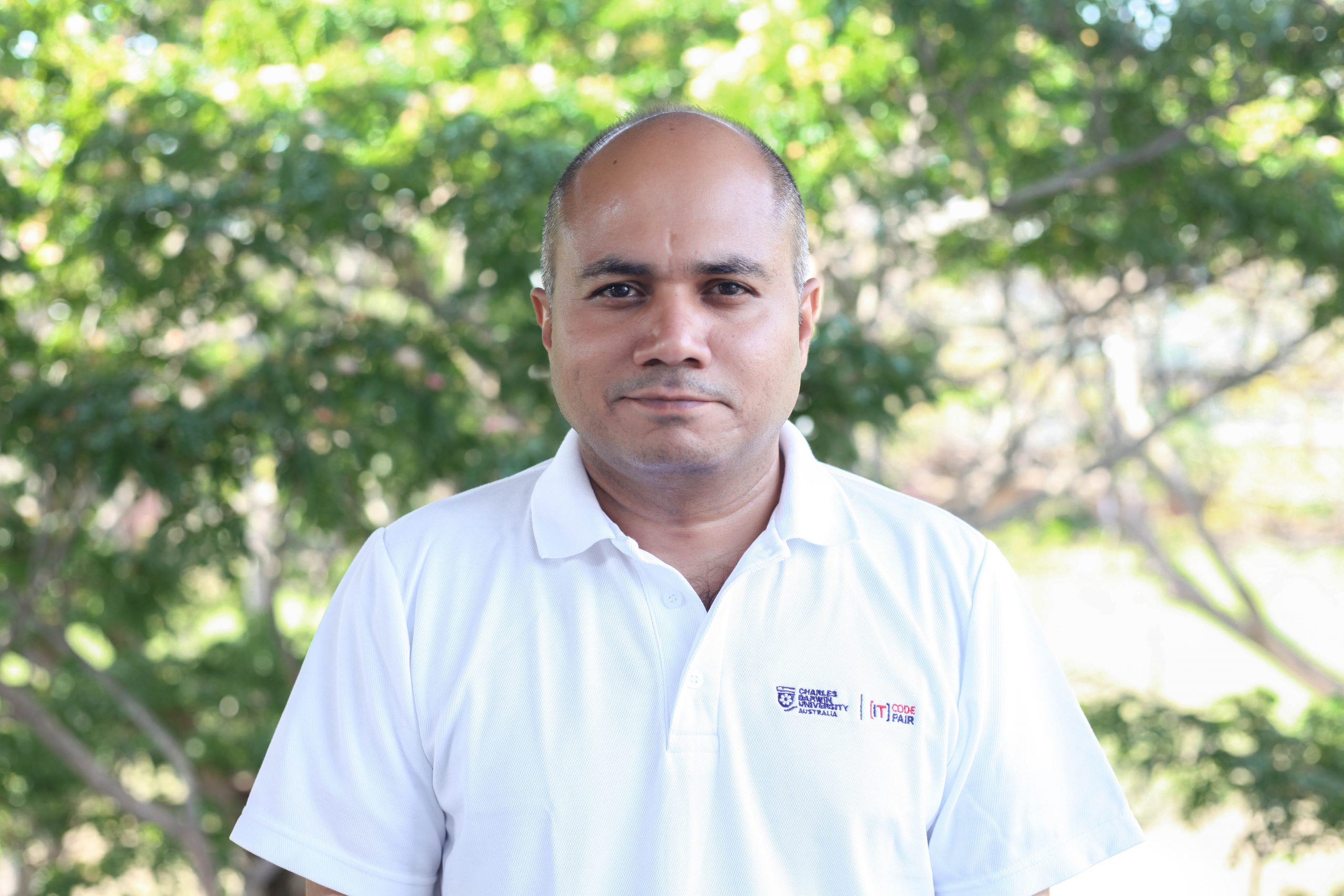
Dr Bharanidharan Shanmugam
Senior Lecturer - Information TechnologyEnergy & Resources Institute
Faculty of Science and Technology

Contact
Thank you for your interest in our citizen science project! Whether you have questions, feedback, or are interested in getting involved, we're here to help.
Location:
RIEL, Building Yellow 2, University Drive North, Casuarina NT 0810
Email:
Jenny.Davis@cdu.edu.au
Call:
08 8946 6463